
Linear Interpolation
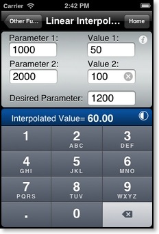
Input the known Parameter 1, Parameter 2, Value 1, Value 2 and the desired parameter . Result is the linear interpolated value.
Used in many performance chart calculations (standing water takeoff, %N1, Stab Trim, RFI, etc.).
Min. Floor Load Limit
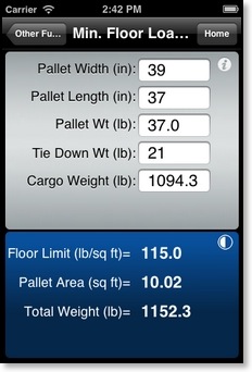
Input the pallet dimensions in inches. Pallet weight, cargo weight and tie down weight in pounds. Result is the minimum floor load limit required to carry the given pallet.
Max. Cargo Weight
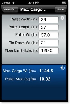
Input the pallet dimensions in inches. Pallet weight and tie down weight in pounds. Floor load limit in pounds per square feet. Result is the maximum cargo weight that can be loaded on the pallet or cargo bin.
Runway Slope
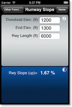
Runway Slope: Enter the runway end elevations and the runway length. The calculated slope is simply the rise over run calculated to a percent value. To change the runway length units from feet to meters select meters for Runway/Visibility(Cargo) Units: in the Main Menu Setup page.
PAX Weights
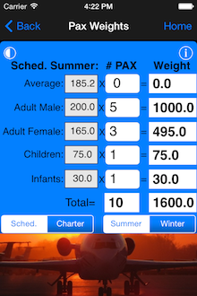
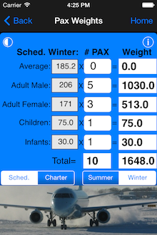
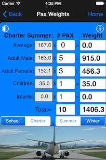
Pax Weights function allows you to enter different Winter/Summer and Scheduled/Charter passenger weights and will automatically total the passenger count and weight.
C.G. Change
Weight to Shift
Distance to Shift
Sunrise/Sunset:
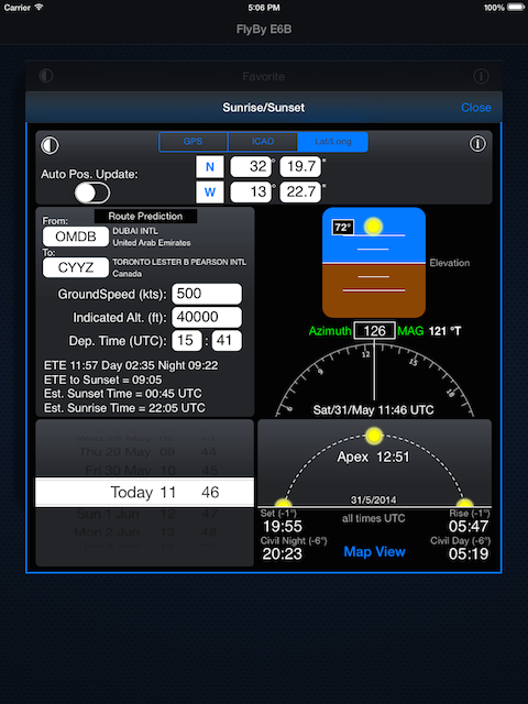
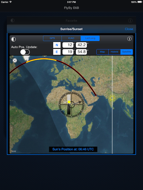
Displays the sun information for any location on earth.
Select any location and UTC time.
GPS selection will use your devices current location. ICAO will use any airport you enter. Lat/Long uses any coordinates that you enter manually. All times are displayed in UTC. The map view will display the selected location and the sun's elevation at that point based on the time and date input. The Lat/Long selection allows you to move the centre of the map to any location in the world. The Azimuth function is very useful in determining if you will be looking directly at the sun when landing. Simply compare your runway heading to the sun's Azimuth after entering your ETA.
The Route Prediction page calculates the estimated sun information for your flight based on an average groundspeed, altitude and time of departure. If an airport is not in the included database you can enter the latitude and longitude values in the Track and Distance module.
Note: Atmospheric refraction can significantly affect the observed Sunrise/Sunset. Rise and set occurs at an elevation of -1 degrees. Calculations are based on sea level. Terrain and altitude are not factored into the sunrise/sunset times. The map view sun icon represents the Apex point (90 degrees).
The date and time are reset to your devices current UTC time each time you enter the Sunrise/Sunset function. If you are using iOS7 or higher you will also see your map track line with the daylight portion in yellow and night segments in black.