
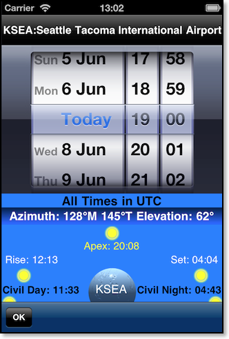
The "SUN" function in FlyBy Nav also calculates Civil Twilight (beginning of Day and Night), High Noon (Apex), and the Sunrise and Sunset times of the sun on the APPARENT HORIZON for a given location. The APPARENT HORIZON is zero degrees (level with the horizon at sea level) and does not take into account any local variations in the ACTUAL HORIZON as seen from an observer at cruise altitude, or from within valleys, or mountain ranges. All times are displayed in UTC. Otherwise known as Greenwich Mean, Zulu or UTC (Co-ordinated Universal Time). These times need to be converted to the local time zone of the specified location.
A special added feature allows you to find the sun's elevation (as seen from sea level) and azimuth (bearing). By entering the appropriate UTC, you will see a display of the sun's elevation at that time. Elevation is displayed in degrees above the Apparent sea level horizon. A negative number for the elevation means the sun is below the horizon. Displayed under the elevation, is the magnetic and true azimuth of the sun. If you pointed your aircraft directly at the sun at the UTC time, you could set your Directional Gyro to the Azimuth displayed. This feature is especially useful in determining if a given runway will have you looking directly into the sun when you land and take-off.
To perform a SUN calculation, you will need to first specify a location where the event is to be observed. From the Search Waypoints screen enter the waypoint ident. Once you have selected the waypoint simply select the "SUN" button in the upper right hand corner of the screen.